Door Creek Park
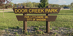
| Address: | 7035 Littlemore Dr. |
| Hours: | 4:00am - 10:00pm |
| Park Type: | Community |
| Acres: | 160.00 |
| Restroom: | Yes |
| Drinking Water: | No |
Park Details
This community park, with nearly 160 acres, is located on Madison's far eastside in the Door Creek neighborhood. First acquired in 1990 and a Door Creek Master Plan approved in March 2008, this park features a reservable shelter, tennis courts with shared pickleball courts, a large playground, basketball courts, hiking trails and multipurpose fields.All Season Trail Map
Winter Recreation
New in 2025-26 - an ice rink and staffed pavilion for cross-country ski, ice skate and snowshoe rentals and concessions as conditions allow. A cross-country ski permit is required at this location. See Winter Fun for updates and more information..jpg)
The land is adjacent to Dane County Parks, Blooming Grove Drumlins Natural Resource Area, North Unit.
Alternate addresses and access points: 6901 Bluff Point Drive, 851 Harrington Drive, 7202 Cottage Grove Rd., 625 Highcliff Trail, between 533 & 601 Highcliff Trail
Park Highlights
Orienteering Course
NOTE: With permission from Madison Parks, this orienteering course was constructed as a one-time, Eagle Scout project in July 2022. The course is not maintained. Please report issues to Madison Parks. We anticipate it will be removed at some point in the future.Orienteering is an activity in which participants use a map and compass to navigate an area and find posted markers. Participants can complete the course competitively or casually, perhaps racing one another or simply finding markers at their leisure.
The orienteering course is ONLY OPEN in the non-winter months, as several markers are placed on cross-country trails.
What you will need:
- Compass
- Orienteering Course map, map image (download or printable)
- Marker symbol sheet (optional, download or printable)
- Pencil (optional)
Using the Map
The map is a very simple guide to finding the markers throughout the park. North on the map is the top edge. On the map, the purple circled numbers denote the locations of the 12 numbered markers, and the purple triangle is the starting and ending point. The circles show a control area with about a 15-foot radius inside of which the marker is located, and the purple lines spanning from marker to marker denote the compass direction from each and to each as the crow flies. The marked trails are still to be followed.Signs/Markers in the Park
Markers consist of a green metal post extending 4 feet out of the ground, with a 6x6 inch orange-and-white sign fastened to the top. The sign has a number on the top left to show which marker it is, and a Greek letter on the bottom right, as shown below.Using the Greek Letters (optional)
If participants wish to run a competitive orienteering race, they can print out the Marker Symbol Sheet in addition to the map. Participants copy down the Greek letter found on the signs to prove that they did in fact find the markers. The sign numbers and their corresponding letters can also be found in the Symbol Key document on this page.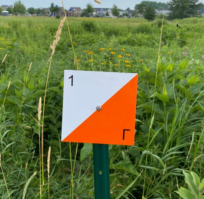
This orienteering course was constructed in July 2022 as an Eagle Scout Project by Zane Brolin and Troop 16.
At this Park
-
 Basketball Court
Check out the hoops in your neighborhood! According to the Trust for Public Land's ParkScore (2025), Madison scores 100 out of 100 points or 9.3 per 10,000 people, for the number of basketball hoops provided to its residents.
View all Basketball Courts
Most of the basketball courts are available on a first-come, first-served basis. If you are planning a new league or tournament
Reserve Online-
Door Creek Park - Basketball Court
Surface: Asphalt
Lighted: No
Number of Courts: 2 full
-
-
 Cross-Country Skiing
Cross-Country Skiing in Madison Parks
Madison Parks offers groomed cross-country ski trails. Three (3) require a permit and three (3) are free to use. The type and frequency of grooming depend on the location and conditions. See Trail Status Definitions for more information. Rentals & Concessions are planned for Door Creek, Elver and Odana Hills as conditions allow. See Staffed Hours below for more information.
Free to Use Parks
- Cherokee Marsh - South, Owen, and Turville Point
- Groomed weekly and/or as conditions allow.
Permit Required Parks
- Door Creek, Elver and Odana Hills Golf Course.
- A daily or annual ski permit is required for anyone aged 16 or older.
- Groomed several times each week for classic (tracks) and skate skiing, as conditions allow.
- Equipment rentals are available when staffed, as weather and trail conditions allow.
Type Ski of Permit Fee Daily $8 Annual $30 Annual Senior (65+), Disabled, Military or Veteran $15 Replacement $15 View all Cross-Country Skiing
- 2026 permit is valid from the time of purchase through December 31, 2026.
- 2027 permit is available starting November 1, 2026, and valid from the time of purchase through December 31, 2027.
- The permit is also valid for Dane County Parks trails.
Staffed Hours: Concessions & Equipment Rentals
Ski rentals and concessions are available from the warming pavilion at Door Creek and Elver and inside the clubhouse at Odana Hills, weather and conditions permitting. Staffed hours are subject to change and dependent on the weather and trail conditions. Be sure to check the Winter Activity Updates alert at the top of the page.Door Creek and Elver
Days of the Week Hours Wednesday - Friday 4:00pm - 8:00pm Saturday 12:00pm - 8:00pm Sunday 12:00pm - 6:00pm Odana Hills
Days of the Week Hours Saturday and Sunday 10:00am - 4:00pm Equipment Rentals
Includes skis, boots, poles and daily ski permitType Price per Hour Adult $9 Youth - age 15 & younger $5 Sit Ski (Elver only) - Adult $9 Sit Ski (Elver only) - Youth - age 15 & younger $5 Each additional hour - adult or youth $5
Events & Group Outings
Attend a winter event open to the community or reserve a winter recreation party for your group. All winter activities depend on the weather and conditions and are subject to change.Pets & Bikes
Bikes and pets are not allowed on cross-country ski trails. Leashed dogs are allowed on the hiking trails.Hiking and Snowshoeing
Do not walk or snowshoe on a designated cross-country ski trail. In general parks, walking/hiking or snowshoeing is allowed anywhere except on cross-country ski trails. In conservation parks, hiking/snowshoeing is allowed on non-cross-country ski trails only. See snowshoeing for suggested locations. We recommend, when in doubt, don't.
Trail Conditions and Grooming
Type of Grooming
The type of trail grooming performed depends on a few things to make the most of both long and short-term skiing opportunities. The amount and type of snow, as well as ground conditions at the time of the snow event, play a role in the grooming equation. Trails may be rolled to compact the snow base and ideally extend the skiing season.
Trail Status Definitions
- OPEN = trail is snow-covered, skiable with the most recent grooming date posted.
- CLOSED = skiing is not advised or permitted
- See Madison Nordic Ski Club for trail conditions posted by volunteers and trail users.
When We Groom
Parks staff is responsible for priority snow removal areas, including roads, more than 400 bus stops, bike trails, sidewalks, and parking lots. We appreciate your patience and understanding as safety will always come before fun.
- Ski trails typically open after the first snowfall over 4", depending on the type of snow and trail conditions.
- Fee-based trails are groomed more frequently, as conditions allow and for both skate and classic skiing.
- Free-to-use ski trails are tracked or roll-groomed for classic cross-country skiing.
- We may not be able to groom or we may close a trail to preserve the trail condition. The website is updated as soon as information from the field is available.
- Permit fees are non-refundable.
- You may also visit Madison Nordic Ski Club for trail conditions posted by volunteers and trail users.
Trail Tips & Responsibilities
- Follow directional arrows. Some trails are marked for one-way use
- Trails are rated for difficulty at the trailhead
- Skiers stay on groomed trails only
- No dogs, horses, snowboards, motor vehicles, hiking or snowshoeing on groomed trails
- Slower skiers, please stay to the right
-
Door Creek Park - Skiing
Location: 7035 Littlemore Dr.
ClosedCross-Country Skiing at Door Creek Park
-
 Hiking
Explore the many scenic trails and pathways throughout Madison Parks. Year-round restrooms are available at Cherokee Marsh, North and Owen conservation parks.
Hiking
Explore the many scenic trails and pathways throughout Madison Parks. Year-round restrooms are available at Cherokee Marsh, North and Owen conservation parks.
MAPS
Looking for a trail map for a particular park? A number of the individual park pages provide a trail map. Check out the "About This Park" section of your favorite park. Don't see a map? Let us know!
Dogs
Most parks allow leashed & licensed dogs with a Dog Permit. However, dogs are prohibited in all conservation parks and a few other locations. See Dog Free Parks for more information. View all Hiking -
 Ice Skating
Ice Skating in Madison Parks
We offer free ice skating in 14 parks, at 20 rinks and designated lagoons citywide. Staffed warming shelters for skate rentals and concessions offered through Thursday, Feb. 12. If ice conditions allow, rinks and lagoons may remain open and maintenance may continue beyond this date. Be sure to check the Winter Activity Updates alert at the top of the page.
Opening an ice rink or lagoon for skating involves careful assessment. Always check the status online or call the Parks office before skating. Each rink and lagoon's status is listed and updated promptly. Rinks/lagoons will close if meltwater is visible to prevent extended closures from damaged ice. See Declaring a Rink or Lagoon as Open for more information.Skate Rentals & Concessions
Ice skate rentals and concessions are available at Door Creek, Elver, Tenney and Vilas, when staffed and based on when a rink/lagoon is listed as open. Example: if the Tenney lagoon is listed as closed, the warming pavilion is closed and not staffed.
Warming Pavilion Staffed Days and Hours
Be sure to check the Winter Activity Updates alert at the top of the page for updates.
Days of the Week Hours Wednesday - Friday 4:00pm - 8:00pm Saturday 12:00pm - 8:00pm Sunday 12:00pm - 6:00pm Staffed hours are subject to change and dependent on the weather and ice conditions. If a rink is closed, we will not be staffed.
Skate Rentals Price per Hour Adult $6 Youth - age 15 & younger $3 Each additional hour $2 Hockey Stick (Elver, Tenney & Vilas) $3
Loaner Skates
Free-to-use ice skates are available at Olbrich, Rennebohm, Warner and Westmorland Parks. Borrow a pair of skates to use while at the rink. Limited quantities and sizes are available from inside the warming shelter. Please wipe down and return before leaving the park.
Hockey Rinks
Madison Parks staff and volunteers maintain groomed hockey rinks with boards at Elver, Tenney, Westmorland, and Vilas. Hockey may be played on other rinks if no other skaters are present. However, general rinks are meant for general ice skating.
Events & Group OutingsAttend a winter event open to the community or reserve a Winter Recreation Outing for your group. All winter activities depend on the weather and conditions and are subject to change.
Restrooms
Indoor and portable restrooms are provided at a number of parks. See Restrooms for open locations.
Pets & Bikes
Bikes and pets, including well-behaved dogs, are never allowed on any ice rink or lagoon. See Dogs in Parks for locations where allowed.
A big thank you to our many volunteers and the Adopt Ice Partnership Program!
View all Ice Skating
-
Door Creek Park - Ice Rink
Location: 7035 Littlemore Dr.
Closed
More Information: Skating at Door Creek Park - Ice Rink
-
-
 Multipurpose Field
Open or Multipurpose Fields are reservable athletic fields with no game-specific design or limitations. Often used for soccer, ultimate, lacrosse or football, yet open to your imagination. Multipurpose Fields are located throughout the city and may be used on a first-come, first-served basis if not already reserved. RESERVE ONLINE
View all Multipurpose Fields
SPECIALIZED FIELDS
Specialized fields include soccer, cricket, ball diamonds - baseball or softball and both fenced and non-fenced, may be viewed on the individual pages. See the sidebar on the Athletics webpage.-
Door Creek Park - Multipurpose Field
-
-
 Parking Lot
Parking lots in parks are available for park programs or events during regular park hours: 4:00 am to 10:00 pm.
Parking Rules
- Driving or parking motorized vehicles is not allowed on the grass or near a shelter and is subject to a citation.
- Three-hour limit in all parks, as posted.
- No parking after hours: 10pm to 4am. Overnight parking is not allowed.
- Conservation park hours are 4am until one hour after sunset
- Follow all onsite parking regulation signs.
- Violators are subject to a fine.
Bus Parking
The City of Madison offers free, bus parking in the rear lot of Duane F. Bowman Park, 1775 Fish Hatchery Road, 53713. See Bus Parking Map for more information. This is the only designated City of Madison parking lot. All other locations, such as Olin Park, Turville Point Conservation Park, and Vilas Park Drive are prohibited and subject to a citation.
Law Park: metered parking stalls
The parking lot located on the eastern side of Law Park, commonly known as the Blair Lot, is a metered parking lot, enforced by City of Madison Parking Division between the hours of 6:00 a.m. and 6:00 p.m. Monday through Friday.
View all Parking Lots -
 Pickleball Court
Pickleball Court Update
- Brittingham Park - fencing work is nearly complete and courts are open again! (as of 11/5/25)
Among the nearly 100 tennis courts in Madison, many are dual-striped for pickleball. Dual-striped courts utilize the tennis net which is about 2" taller than a standard pickleball net. Garner Park offers Madison's only dedicated pickleball courts.
While the courts are available for individuals on a first-come, first-served basis, ALL LEAGUES AND LESSONS MUST RESERVE IN ADVANCE. RESERVE ONLINE View all Pickleball Courts-
Door Creek Park - Pickleball Court
Surface: Asphalt
Lighted: No
Number of Courts: 8
Notes: Tennis/Pickleball Courts (8)
-
 Playground
With more than 175 playgrounds throughout Madison, you are never too far from a playground. According to the Trust for Public Land's ParkScore (2025), Madison scores 100 out of 100 points or 32.6 per 10,000 children, for the number of basketball hoops provided to its residents.
Playground for Everyone
Through the Madison Parks Foundation initiative, Madison Parks offers accessible playgrounds in Brittingham, Elver, Rennebohm and Warner parks. An accessible playground is anticipated in Reindahl Park in the near future.
Nature Playgrounds
A nature playground uses natural materials such as logs, rocks, plants, and the surrounding land to create a play environment that encourages children to explore and connect with nature. Nature play elements can combined with traditional playground equipment like slides, swings and climbers. Check out Brittingham Park and Olbrich Park to get you started, other parks include Paunack, Garner, Tenney, Westmorland and Wingra.
Playground Replacements: How and When
Madison Parks is responsible for maintaining more than 175 playgrounds and began a system-wide replacement initiative in 2013. With current staff and funding resources, replacements are scheduled to continue through 2033. Playgrounds are routinely inspected to assess the equipment's condition and repair any safety concerns. Based on the age of the equipment and current conditions, each is given an audit score. The number of playgrounds replaced each year is based on budget allocations, staffing resources, and the current playground audit score for prioritization.
Replacement Process: Neighborhood Input
At the start of the replacement process, notices are sent to the District Alder, neighborhood association representatives, and surrounding residential addresses. Information is also posted to the project website. Generally, two public meetings are held to review surfacing and equipment options and make final selections.
View all Playgrounds
If you have questions about a specific playground or see something broken, please let us know.-
Door Creek Park - Playground
-
-
 Restroom
Restroom UPdates
- Seasonal restrooms open Saturday, April 25, 2026.
- Warner Park Boat Launch Restrooms - Due to maintenance issues, the restrooms are closed. Initial findings of the boat launch building found extensive settling issues causing the plumbing to break apart and fail. This project will be managed by City Engineering. The restrooms will remain closed until further notice and portable unit is onsite.
Restrooms across the park system are available year-round and seasonally from late April to early October. Indoor restrooms are open approximately 11:00 am to 8:00 pm during the winter season. The website lists OPEN locations.
Seasonal Closures - October - April
Hard freezes can occur at any time in October. A hard freeze is defined as temperatures dropping to 28°F or below. In 2024, this happened on October 15. As such, staff must prepare by closing and winterizing restrooms and drinking fountains. This system-wide process takes weeks to complete. Additionally, we no longer have seasonal staff for regular cleaning. Seasonal restrooms will reopen Saturday, April 25, 2026.Open Year-Round
- Brittingham Park (2) at beach house and boat house+
- Cherokee Marsh Conservation Park - North*
- Cherokee Marsh Conservation Park, South+
- Door Creek Park+
- Elver Park enclosed shelter*
- Hiestand Park - near disc golf course+
- Owen Conservation Park*
- Warner Park boat launch*
Open for Winter Recreation
In addition to the open year-round locations, we plan to have open restrooms at popular winter recreation locations. Note: indoor restrooms remain closed until the winter amenity is open.- Goodman - ice skating+
- Heritage Heights - ice skating+
- Olbrich - ice skating*
- Rennebohm - ice skating
- Turville Point Conservation Park - skiing+
- Vilas - ice skating, snowshoeing* (inside shelter, open when staffed)
- Warner - ice skating*
- Westmorland - ice skating*
+ADA Accessible Portable
NOTE: Portable toilets not identified on this page are most likely arranged by a user group, such as an athletic organization and may not be accessible. All portable restrooms identified on the page are arranged by Madison Parks and are ADA accessible.
View all Restrooms-
Door Creek Park
OPEN
-
 Shelter - Reservable
Shelter News
- Olin Park Pavilion Bonus Reservations - Great news! With an updated Olin Park Pavilion – Normal Hall rehabilitation project schedule, we are able to offer Bonus 2026 Reservations - Saturday, April 25 through Wednesday, Sept. 30, 2026! If you are interested in reserving the Olin Park Pavilion, reservations will open at 8:00am, Tuesday, April 7, and may be made online or by phone.
- Hoyt Park Shelters Closed 2026 - both shelters closed through August 2026 due to the parking lot reconstruction. See Hoyt Park project for more info.
- 2027 reservations open on Monday, November 2.
Park shelters and pavilions, ideal for casual events, staff retreats, or celebrations, are available to reserve generally mid-April to mid-October. There are some exceptions noted below.
Steps to Reserve a Shelter
- Review RESERVATION POLICIES and SHELTER PRICES.
- Review Parks Projects. As we continually improve our park system, some projects may impact a nearby shelter.
- Reserve one of three ways. Full payment is due upon processing.
- ONLINE - credit card only
- Calling 608-266-4711 - credit card only
- In-person at the Parks Lakeside Offices - credit card, cash or check (made payable to City Treasurer)
Important Notes
- Any required permits, such as amplified sound, or alcohol are required at the time of processing.
- All reservations are subject to our standard cancelation policy.
- Opening day to reserve a park shelter for the following year begins on the first business day in November.
- 2027 reservations open on Monday, November 2, 2026.
- IMPORTANT: Canceling a reservation made on opening day will result in a 50% refund and must be submitted at least 11 or more days before the event date. No refunds are given if the request is submitted 10 days or fewer before the event.
- Dogs are prohibited inside a shelter or other City building.
- Picnic shelters may be reserved online or by calling -OR- if not reserved, are available on a first-come, first-served basis. Day of signage is posted at the shelter.
- Madison Parks does not guarantee absolute privacy to any group. Your reservation will reserve only the facility you are using, not the entire park or other park amenities. If you are interested in reserving the entire park, please visit Special Events.
- Alcohol is permitted in most Madison Parks. Glass is never allowed. There are a handful of alcohol-free parks. In these locations, if you would like to bring alcohol, you will need an alcohol permit, which may be obtained when placing your reservation. An alcohol permit, without a reservation, is not given.
- Public improvements and/or construction may be underway during the time of your reservation. The City of Madison Parks Division makes every attempt to schedule around events and shelter reservations whenever possible; however, this is not a guarantee. Please keep in mind improvements to parks and infrastructure continue throughout the year. Please visit Park Projects for a partial list of major capital improvement projects.
- Firearms or weapons are not permitted at any of the shelters. Violators may be considered trespassers and may be subject to forfeiture or arrest.
Open Schedule Exceptions
- Open year-round:
- Open mid-April through the end of October:
- Door Creek Park
- Elvehjem Park
- Elver Park (enclosed shelter)
- Olin Park (open through Sept. 30, 2026)
- Penn Park
- John Wall Family Pavilion in Tenney Park (open through mid-November)
- Vilas Park
- Warner Park ("rainbow" shelter)
- Westmorland Park
-
Door Creek Shelter
Address: 7035 Littlemore Dr
Capacity: See Seating Notes
Restrooms: In shelter
Water: Available in shelter
Parking: Parking lot
Shelter Details: Door Creek Shelter
-
 Snowshoeing
Snowshoeing in Madison Parks
Experience winter in Madison Parks like never before with snowshoeing! This silent sport is a fantastic way to explore many of our parks during the winter months and is easy to learn. In general parks, snowshoeing is allowed anywhere with good snow cover; typically, this means at least 6" or more. Snowshoeing is not allowed off-trail in a conservation park or on a designated cross-country ski trail.2025-26 Designated Snowshoe Trail Maps
Snowshoe Rentals & Concessions
Concessions and snowshoe rentals are offered as conditions allow at the staffed warming pavilion at Door Creek, Elver and Vilas parks. See Cross-Country Ski for hours and status.Hourly Rentals
Available from Door Creek, Elver and Vilas.Type Price Adult $5/ hour Youth - age 15 & younger $3/ hour Each additional hour (adult or youth) $2/ hour Daily Rentals
Longer-term snowshoe rentals are available from Elver and VilasType Price Adult $25/ day; $15 each additional day Youth - age 15 & younger $10/ day; $5 each additional day Where to Snowshoe Guidelines & Tips
- Anywhere with good snow cover, on or off-trail, in a general park that is not a designated cross-country ski trail.
- On trail only, in a conservation park, that is not a designated cross-country ski trail.
- Snowshoeing, hiking, and skiing off-trail can destroy snow tunnels used by native small rodents (deer mice, shrews) due to trampling. These small mammals are an important part of the wetland and grassland ecology in our conservation parks. Destruction of these tunnel networks makes small mammals more vulnerable to predation.
- When in doubt, it's always best to stay on a trail.
- Our trail systems are designed to facilitate controlled public access while protecting environmentally sensitive areas and providing a quiet refuge for wildlife away from people. Disruption of wildlife by human activity during winter adds to the stress they face during a challenging time for their survival.
-
 Tennis Court
Tennis Court Updates
- Brittingham Park - fencing work is nearly complete and courts are open again! (as of 11/5/25)
- Rennebohm Park - west court construction is substantially completed and courts are open for play! (updated October 20, 2025)
Madison Parks offers nearly 100 tennis courts, many are dual-stripped for tennis and pickleball. While the courts are available for individuals on a first-come, first-served basis.
Important: All leagues must reserve in advance. Reserve Online
Practice Wall Locations
Bordner, Brittingham, Elver, Olbrich, Tenney, Waunona and Westmorland
Vilas Park Tennis Courts (as of April 30, 2024)
Due to the deteriorating conditions and safety concerns, the Vilas Park tennis courts are closed. View all Tennis Courts-
Door Creek Park - Tennis Court
Surface: Asphalt
Lighted: No
Number of Courts: 8
Notes: Tennis/Pickleball Courts (8)


