Southeast Area Plan
Madison Madness!!!
It's that time of year again and the City of Madison is getting into the spirit with a new way for residents to share their perspectives. The “Madison Madness” bracket takes aspects of future planning – like housing, neighborhood amenities, transportation, and recreation – and puts them into a bracket format, allowing residents to think about their priorities and share them with the City in a fun and unique way.
Each “team” in the bracket represents a component of what the future of the city could be. The bracket’s four “regions” represent a different area of focus: Neighborhood Destinations, Places to Live, Streets and Getting Around, and Open Spaces and Recreation. Each “region” is broken down into eight different aspects of those categories. There are 32 items in the bracket overall.
The survey will take you through each “matchup” individually. In each matchup, you’ll choose what the higher priority is for you. The survey will keep presenting you with matchups as you work your way through the bracket until you have your “champion” -- the biggest priority you’d like to see addressed.
Fill out your bracket and tell us your perspectives!
El Municipio de la Ciudad de Madison está planeando el futuro de la ciudad y actualmente se centra en las áreas Sureste y Suroeste. Para comprender mejor sus opiniones y preferencias sobre cómo Madison podría crecer y cambiar, hemos creado un juego tipo torneo. Cada equipo representa parte de una posible visión de futuro para la ciudad. Díganos qué es más importante para usted seleccionando su equipo preferido en cada enfrentamiento. Los equipos que no avancen no quedan excluidos, pero coronar a su campeón nos ayuda a comprender las prioridades de la comunidad. Cada selección de equipo tiene un enfoque diferente: Destinos del Vecindario, Lugares para Vivir, Calles y Transporte, y Espacios Abiertos y Recreación.
Complete su formulario en línea y obtenga más información sobre los Planes de Área del Sureste y Suroeste. ¡Asegúrese de incluir su correo electrónico para recibir actualizaciones del proyecto!
---
Southeast Area Community Survey
Thank you to everyone who participated in the Southeast Area Plan survey! Staff is compiling and reviewing the results. Once the results of survey are compiled a second survey will be created based on the feedback received. The second survey will be sent out in the spring. Survey results will be posted on this page later this spring.
Commenting Map
Share what you love about the Southeast Area, along with your ideas and feedback on things that need attention on the Southeast Area Plan interactive commenting map.
The Southeast Area Plan
Area Plans guide changes that occur over time to the physical aspects of our community, such as land use, housing, transit, streets, bike paths, and other community facilities. They are steered by overarching City policies and feedback from stakeholders.
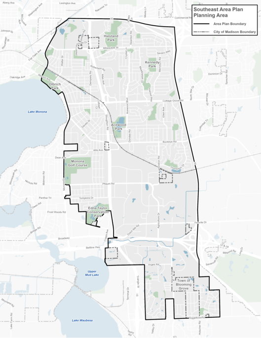
The Southeast Area is approximately 7,000 acres (10.9 square miles) and is generally bounded by the State Highway 30 to the north, Interstate 90 to the east, City of Monona to the west, and Siggelkow Road / Village of McFarland to the South. See map below. Additional background maps can be found under the Project Resources section.
The City invites residents, community organizations, businesses, and other stakeholders to share feedback about the future of their neighborhoods. Keep up to date on events and ways to participate by subscribing to the email list.
Subscribe to Email List
Meetings
Upcoming
Past
Open House - Dec 4, 2024
Presentation, Boards, Handouts
Virtual Meeting - Dec 5, 2024
Presentation, Meeting Recording
Project Resources
Background
Land Use & Transportation
Neighborhood Housing
Economy & Opportunity
Culture & Character
Green & Resilient
Effective Government
Health & Safety
Community Action Strategy
Project Contacts
Rebecca Cnare, City of Madison Planning Division
Jeff Greger, City of Madison Planning Division
Phone: 608-266-4635
Email: southeastareaplan@cityofmadison.com