
Southwest Area Plan

The final draft of the Southwest Area Plan is available!
Southwest Area Plan Final Draft
The final draft was introduced to the Common Council at its May 5, 2026 meeting. It was referred to the Boards, Commissions, and Committees listed below, which may propose changes to the plan before the Common Council makes a decision on final approval.
Each Board, Commission, and Committee meeting during the adoption process will provide the opportunity for public comment. Agendas and instructions on how to register for public comment — both spoken and written comments — are typically posted the Friday prior to each meeting. Agendas will be posted on the meeting notice pages linked in the timeline below.
An amendment to the Comprehensive Plan is being considered at the same time to integrate Southwest Area Plan material into the Comprehensive Plan.
Get Engaged
Subscribe to Email Updates
The best way to stay up to date on the Southwest Area Plan is to join the email list. The list is our primary way of announcing meetings and communicating other project updates for the Southwest Area Plan.
Plan Area
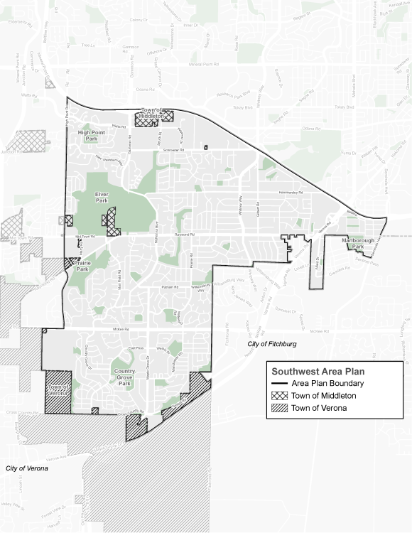
The Southwest Area is generally bounded by the West Beltline Highway to the north, the City of Fitchburg to the east, and S. High Point Road to the west.
Past Meetings and Events
Past Community Meetings and Engagements
- November 19, 2024 - Open House
- December 3, 2024 - Virtual Meetings
- Madison Madness
- Survey Part 1 | Survey Part 2
- May 27, 2025 - Neighborhood Walk #1
- June 4 & 5, 2025 - Bike Week at SW Path at Hammersley
- June 10, 2025 - Neighborhood Walk #2
- July 23, 2025 - Art Workshop
- October 23, 2025 | Open House
- October 29 & 30, 2025 | Virtual Meetings
Past Commission and Committee Meetings
- June 2, 2025 - Plan Commission - Video
- June 25, 2025 - Transportation Commission - Video
- December 3, 2025 - Transportation Commission - Slides | Video
- December 4, 2025 - Community Development Block Grant Committee - Video
- December 10, 2025 - Board of Park Commissioners - Slides | Video | Memo
- December 15, 2025 - Plan Commission - Slides | Video | Memo
- December 17, 2025 - Economic Development Committee - Slides | Video | Memo
Project Resources
Reference, background and learning resources will be posted here as they are prepared.
Maps
- Background
- Land Use & Transportation
- Neighborhood Housing
- Economy & Opportunity
- Culture & Character
- Green & Resilient
- Effective Government
- Health & Safety
- Community Action Strategy
Background Information & Handouts
- Project Timeline
- Underlying Plan Review
- Frequently Asked Questions
- Zoning District Summary
- Storymap #1: the Southwest Area
- Storymap #2: draft action and map highlights